Ross Sea region Marine Protected Area (RSr MPA)

Established

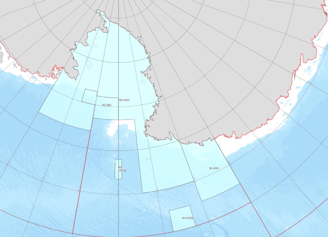
The Ross Sea region Marine Protected Area (RSr MPA) was originally proposed in 2012, and agreed by CCAMLR in 2016 under CM 91-05, with the MPA coming into force on 1 December 2017. The RSrMPA is the world’s largest MPA covering 2.09 million square kilometres. The MPA is divided into three zones, the General Protection Zone (GPZ), the Special Research Zone (SRZ) and the Krill Research Zone (KRZ), each of which allows certain activities and restricts others. Fishing activities are prohibited within much of the MPA with a few exceptions, all of which must be conducted in accordance with other Conservation Measures set down by CCAMLR.

The MPA aims to protect large-scale ecosystem processes, conserve biodiversity, protect predators and prey (including penguins, seals, whales, krill and Antarctic silverfish), protect areas of ecological importance, protect areas that are important to the life cycle of Antarctic toothfish, and promote research and other scientific activities (such as monitoring) on the marine living resources in the region. The RSrMPA remains in force until the end of its review period in 2052, at which time it may be renewed or modified as needed.

The specific objectives for the research and monitoring plan associated with the RSrMPA fall into three main categories:

(i) representativeness - research and monitoring to assess whether the RSrMPA is protecting an adequate proportion of all benthic and pelagic environments in the Ross Sea region

(ii) threat mitigation - research and monitoring to assess the extent to which threats to the achievement of Article II.3 and the specific objectives of the RSrMPA are being effectively avoided or mitigated by the MPA, in locations where the risk of ecosystem impacts from harvesting activities may otherwise be high

(iii) scientific reference areas - research and monitoring where the RSrMPA provides opportunities to examine Antarctic marine ecosystems where no, or limited, fishing has taken, or is taking, place, to understand, for example, the effects of fishing, environmental variability and climate change on Antarctic marine living resources.

R = Representativeness, T = Threat Mitigation, S = Scientific Reference Areas
  • (i) Conserve natural ecological structure (R, T, S)
  • (ii) Scientific reference areas - Special Research Zone (SRZ) (S)
  • (iii) Promote research (R, T, S)
  • (iv)a Representativeness of benthic and pelagic environments - benthic bioregionalisation (R)
  • (iv)b Representativeness of benthic and pelagic environments - pelagic bioregionalisation (R)
  • (v)a Large scale ecosystem processes/ areas - Ross Sea shelf front intersection with seasonal ice (T)
  • (v)b Large scale ecosystem processes/ areas - Polar Front (T)
  • (v)c Large scale ecosystem processes/ areas - Balleny Islands and proximity (T)
  • (v)d Large scale ecosystem processes/ areas - Ross Sea polynya Marginal Ice Zone (T)
  • (v)e Large scale ecosystem processes/ areas - Eastern Ross Sea multi-year ice (T)
  • (vi)a Trophically dominant pelagic prey species - Antarctic krill core distribution (T)
  • (vi)b Trophically dominant pelagic prey species - Crystal krill core distribution (T)
  • (vi)c Trophically dominant pelagic prey species - Antarctic silverfish core distribution (T)
  • (vii)a Key top predator foraging distributions - Adélie penguin summer core foraging distribution (T)
  • (vii)b Key top predator foraging distributions - Emperor penguin summer core foraging distribution (T)
  • (vii)c Key top predator foraging distributions - Weddell seal summer core foraging distribution (T)
  • (vii)d Key top predator foraging distributions - Type C killer whale core summer foraging distribution (T)
  • (viii)a Coastal/ localised areas of particular ecosystem importance - Southern Ross Sea shelf persistent (T)
  • (viii)b Coastal/ localised areas of particular ecosystem importance - Coastal polynyas (T)
  • (viii)c Coastal/ localised areas of particular ecosystem importance - Terra Nova Bay (including the TNB polynya) (T)
  • (viii)d Coastal/ localised areas of particular ecosystem importance - Victoria coast, coastal buffer and platelet ice formation (T)
  • (viii)e Coastal/ localised areas of particular ecosystem importance - Pennell Bank polynya (T)
  • (ix)a Dissostichus mawsoni life cycle areas - Sub-adult toothfish settlement areas on the Ross Sea shelf (T)
  • (ix)b Dissostichus mawsoni life cycle areas - Dispersal trenches for maturing toothfish (T)
  • (ix)c Dissostichus mawsoni life cycle areas - Adult feeding areas on the Ross Sea continental slope (T)
  • (ix)d Dissostichus mawsoni life cycle areas - Toothfish spawning/ life cycle (T)
  • (x)a Rare or vulnerable benthic habitats - Balleny Islands and adjacent seamounts (T)
  • (x)b Rare or vulnerable benthic habitats - Admiralty Seamount (T)
  • (x)c Rare or vulnerable benthic habitats - Cape Adare proximity continental slope (T)
  • (x)d Rare or vulnerable benthic habitats - Southeast Ross Sea continental slope (T)
  • (x)e Rare or vulnerable benthic habitats - Southern McMurdo Sound (T)
  • (x)f Rare or vulnerable benthic habitats - Scott Seamount (T)
  • (xi) Promote research of Antarctic krill - Krill Research Zone (KRZ) (S)
RSRMPA Baseline Data (V1)

Baseline data layers used for spatial planning, monitoring and research in relation to the Ross Sea region Marine Protected Area - Refer to WS-SM-18/01

Data and Resources
Filename
Description
Data layers used to define the key Ross Sea region ecosystem processes used in the Ross Sea region design, and identified in the Ross Sea region MPA research and monitoring plan
Data layers used to define the Ross Sea region pelagic and benthic bioregionalisations
The Ross Sea region pelagic and benthic bioregionalisations (Sharp et al., 2010). These layers are submitted as Arc-GIS vector shapefiles.
Additional data layers deemed potentially useful for defining the Ross Sea region environment and ecosystem baseline. These layers are submitted as spatially-referenced netCDF raster files.
A catalogue of the data layers relevant to establishing the baseline for the Ross Sea region Marine Protected Area (MPA). Data used to investigate environmental and ecological spatial patterns as part of the design and evaluation process for the Ross Sea region MPA, including spatial maps and information on key Ross Sea ecosystem processes, and data layers used to determine the pelagic and benthic bioregionalisations. Also included, the data layers which are considered likely to be useful in contributing to defining the “baseline” state of the Ross Sea region
RSRMPA Baseline Data (V2)

Updated baseline data layers used for spatial planning, monitoring and research in relation to the Ross Sea region Marine Protected Area - Refer to SC-CAMLR-XXXVII/11 and SC-CAMLR-XXXVII/BG/13

Data and Resources
Filename
Description
Top level folder of resources (readme, metadata and summary data)
Unzip this zip archive below 1 - the readme metadata folder
1. Bioregionalisation and mapping biodiversity
2. Physical and biological changes to important habitats, including those related to ocean circulation, acidification, sea-ice, variations and trends in primary production and carbon sequestration, and climate change
3. Functional ecology (i.e. process studies to understand the origin of ecological patterns and processes at all scales)
4. Evolutionary biology (i.e. process studies to understand the origin of observed patterns in biodiversity)
5. Effects of spatio-temporal variation in fishing effort, tagging rates, and fish movement on the Antarctic toothfish stock assessment
6. Trends in Antarctic krill, crystal krill, and Antarctic silverfish populations and demographic processes in relation to physical drivers, climate change, and possible fishery effects
7. Effects of changes in the availabilities of Antarctic krill, crystal krill, Antarctic silverfish, and Antarctic toothfish on their respective predators (e.g. Weddell seals) in relation to fishing, physical forcing, and climate change
8. Distributions and movements of Antarctic toothfish and their predators in relation to their respective ontogenies and population structures and possible fishing and environmental factors
9. Vertical and season distributions of Antarctic toothfish, with effects on availability to capture by predators and fisheries
10. Dependence of Antarctic krill, crystal krill, Antarctic silverfish, and their predator populations on key coastal habitats
11. Population structure (including genetic variation), distribution, and ecological roles of Antarctic toothfish in the coastal margins and southern shelf compared to the continental slope and other offshore areas
12. Factors necessary for successful Antarctic silverfish spawning, including spatio-temporal distribution of spawning and nursery grounds
13. Factors responsible for spatio-temporal patterns of enhanced trophic productivity at retreating marginal ice edges and in polynyas within context of climate change
14. Variation in Antarctic toothfish recruitment, with links to environmental effects, ecological factors, and fishing
15. Importance of areas under sea-ice and the Ross Ice Shelf and other ice shelves for Antarctic krill, crystal krill, Antarctic silverfish, and Antarctic toothfish (e.g. for dispersal or protection from mammalian predators)
16. Factors affecting the spatio-temporal distribution, abundance, density, swarming behaviour and composition of Antarctic krill, and extent that these patterns affect/reflect top-down effects of niche differentiation by pelagic top predators/fisheries
17. Movements and foraging requirements of crabeater seals and emperor penguins in the eastern Ross Sea region
18. Composition, abundance, condition, and ecology of the demersal fish community, including effects of predation by Antarctic toothfish and of different toothfish densities
19. Effects of local exploitation rates and variations in Antarctic toothfish density on the size, condition, age composition, growth, and ecological roles of toothfish
20. Potential Antarctic toothfish spawning on the Ross Sea slope
21. Structure, function, distribution, diversity, and abundance of benthic communities, including potential fishing impacts on benthic invertebrates and prevalence of vulnerable marine ecosystems
22. Ecological role of Antarctic krill in demersal slope environment
23. Dependence of local biota on habitats, sea-ice, and oceanographic conditions occurring around the Balleny Islands, including likely effects of climate change
24. Pelagic prey targeted by mobile top predators in the vicinity of the Balleny Islands, including the foraging ecology of cetacean stocks (e.g. East Australian humpback whales) and their dependence on these prey resources
25. Historic and climate factors accounting for the presence and abundance of chinstrap penguins and other air breathing predators in the Balleny Islands
26. Potential endemic or regionally anomalous benthic communities associated with the Balleny Islands
27. Potential importance of the Balleny Islands as nursery areas for Antarctic toothfish and Antarctic silverfish, including population structures relative to, and connectivities with, other areas in the RSR
28. Timing, frequency, and duration of Antarctic toothfish spawning migrations to the northern Ross Sea region, including sex-specific effects, potential spawning-site fidelity, potential effects on stock assessment, and physical drivers
29. Spawning behaviour and dynamics of Antarctic toothfish, including trends in abundance of fish in various body conditions (e.g. "axe-handle" fish) and potential effects on spawning performance
30. Factors affecting recruitment of Antarctic toothfish, including egg and larval advection and dispersal, post-larval settlement, and physical drivers
31. Environmental factors and physical drivers that determine the distribution and abundance of benthic organisms and community diversity on seamounts, including potential effects of climate change
32. The potential importance of benthic habitats and invertebrate communities to Antarctic toothfish
33. Endemic or regionally endemic benthic communities associated with the environmental setting and geographical positions of seamounts, including Scott and Admiralty seamounts
34. The distribution and stock structure of Antarctic toothfish on Scott and Admiralty seamounts, around the Balleny Islands, in northwestern and northeastern seamount areas, and further north into the South Pacific (north of 60 S)
35. The dependence of pelagic top predators on localised, predictable hotspots of krill abundance and krill swarm composition, and potential impacts from local competition with fisheries
36. Relative distributions, biomasses, and ecological roles of Patagonian and Antarctic toothfish in the northwestern Ross Sea region, and likely effects of fishing
37. Representativeness of benthic habitats in the northwestern Ross Sea region
38. Spatial dynamics and demography of Antarctic krill, including physical drivers and effects of climate change